The Azores sits at a triple junction of three tectonic plates and the archipelago is geologically alive. The nine islands explained, the recent eruptions, and what active volcanism looks like at ground level.
The Azorean archipelago sits at a triple junction of three tectonic plates: the North American, the Eurasian, and the African. The plates are pulling apart, magma is rising into the gap, and the nine islands are the volcanic peaks that have grown high enough to break the surface of the Atlantic. The most recent surface eruption was in 1957 (the Capelinhos event on Faial). Several volcanoes are considered active. The archipelago is geologically alive.
This guide covers the tectonic setting, the volcano types of each island, the historic eruptions documented since settlement in 1432, and the geothermal features you can see today.
The triple junction, in plain terms
Three tectonic plates meet under the Azores.
| Plate | Direction it moves | What that does at the Azores |
|---|---|---|
| North American | West, away from Europe | Pulls apart from the Eurasian |
| Eurasian | East, away from N. America | Pulls apart from the N. American |
| African | North-east | Slides past the others diagonally |
The boundary between the North American and Eurasian plates runs through the middle of the archipelago, passing between Flores and Corvo (which are on the North American plate) and the rest of the islands (which are on the Eurasian and African plates). This fault zone is the Mid-Atlantic Ridge, the same spreading centre that runs the length of the ocean and produces Iceland in the north.
The active spreading rate is around 2 centimetres per year. Slow on human timescales. Geologically: frenetic.
The nine islands and their volcano types
| Island | Volcano type | Last surface eruption | Notes |
|---|---|---|---|
| Santa Maria | Eroded shield | Extinct (>5 Myr) | Oldest island, no recent activity |
| São Miguel | Multiple stratovolcanoes | 1652 (Fogo) | Three active volcanoes |
| Terceira | Stratovolcano + shield | 1761 | Active hot field at Furnas-da-Lava |
| Graciosa | Stratovolcano | Extinct historically | Active fumarole at Furna do Enxofre |
| São Jorge | Linear fissure ridge | 1808 | Cone alignment, recent quakes |
| Pico | Stratovolcano | 1718 (lower slopes) | Highest peak in Portugal, 2,351 m |
| Faial | Stratovolcano + cone | 1957 (Capelinhos) | Most recent surface eruption |
| Flores | Eroded composite | Extinct historically | Old volcanic peaks, deeply weathered |
| Corvo | Single stratovolcano | Extinct historically | One volcano, one caldera, one lake |
Three of the nine islands have had eruptions since settlement (Faial, Pico, São Miguel). The others are considered dormant or extinct on the timeframe of historical record.
The most recent eruption: Capelinhos (1957)
In September 1957, a submarine eruption began 1 kilometre offshore from the western tip of Faial. Over 13 months, lava and ash built a new peninsula attached to the existing island. The eruption buried half the village of Capelo under 30 metres of ash, and the disruption triggered a wave of Faial emigration to North America (the Capelinhos Visa).
Today the Capelinhos site is the most visitable evidence of ongoing Azorean volcanism. The black ash-and-lava cone, the half-buried lighthouse (now a museum), the protected geological trail across the new land. Worth a half-day on Faial.
The active hot fields you can visit
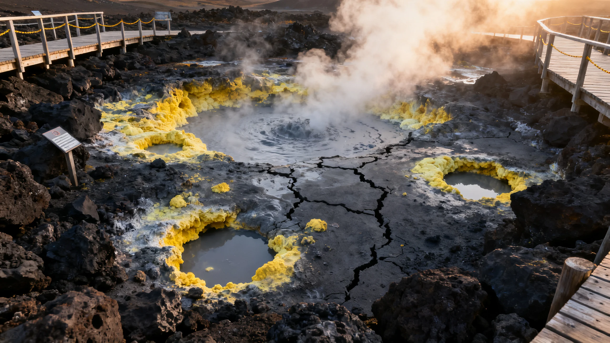
Even when surface volcanism is dormant, the underlying magma chambers keep heating water. The result: fumaroles, hot springs, mud pots. Five places to see this at ground level.
1. Furnas caldeiras (São Miguel)
The most accessible. The geothermal field on the north shore of Furnas Lake includes 22 named fumaroles, several boiling mud pots, the cozido cooking pits (see the hot spring day fiche), and the Água Santa drinking spring. The whole field is fenced and signposted. CO₂ and H₂S concentrations are measured continuously.
2. Capelinhos volcano (Faial)
The 1957 eruption site. Walking trails cross the new land. The visitor centre (built into the half-buried lighthouse) explains the event in detail. Half-day visit.
3. Furna do Enxofre (Graciosa)
A 220-metre-deep cavern inside the Graciosa caldera, with a fumarole field at the bottom. Reached via a descending spiral staircase from the entrance. The cavern is the only one of its kind in Europe. Access via guided tour from the visitor centre.
4. Furnas-da-Lava (Terceira)
The 1761 lava field on the central plateau of Terceira. A short loop trail crosses the dark basalt, with explanatory boards. Less spectacular than Capelinhos but instructive.
5. Fumarolas das Lagoinhas (São Miguel)
A second smaller fumarole field above Ribeira Quente on the south coast. Less visited than Furnas, often empty. Reached via a 2-km trail from the village.
Earthquakes and ongoing activity
The archipelago has small earthquakes constantly (most below magnitude 2, imperceptible). Significant events:
- 1980 Terceira earthquake (M 6.9), 71 dead, widespread damage to Angra do Heroísmo
- 1998 Faial earthquake (M 5.8), 9 dead, damage to villages on the central plateau
- 2022 São Jorge swarm: thousands of small earthquakes over several months, no surface eruption but elevated alert level
The Centro de Vulcanologia e Avaliação de Riscos Geológicos (CVARG) at the University of the Azores monitors seismic activity in real time. The data is public.
What this means for travellers
For a normal short visit, almost nothing. The chance of a significant volcanic event during a typical week-long trip is essentially zero, and even a low-level earthquake swarm produces no surface effects.
The geothermal fields are well-managed and safe behind the established perimeters. Air quality near fumaroles is monitored. Hiking trails near active features are mapped and signposted.
The thing the volcanism does change is the texture of the trip. The black-sand beaches, the warm thermal pools, the cozido cooked underground, the steam visible from the rim road in Furnas: all of this is the same magmatic system, just at different distances from the surface. You are walking on geology that is still working.
Frequently asked questions
How likely is an eruption during my visit?
Effectively zero. Surface eruptions happen on the scale of one per 50 to 100 years. The CVARG monitoring system would detect precursors weeks ahead of any significant event. Authorities would restrict access to risk zones long before any traveller saw lava.
Can I see lava?
Not active lava. The last surface flow was 1957. Cooled basalt lava fields are visible at Capelinhos (Faial), Furnas-da-Lava (Terceira), and along the entire south coast of Pico (lava plates from the 1718 eruption). For active lava, Iceland or Hawaii are the destinations.
Are the islands sinking or rising?
Both, at different times and places. The newer volcanic terrain (Pico, Faial) is still uplifting slowly. The older islands (Santa Maria) are subsiding as the underlying crust cools. The differential rates are millimetres per year.
Why is Pico so much taller than the other peaks?
Pico is a single stratovolcano that built up over 200,000 years without significant collapse. At 2,351 metres it is the highest peak in Portugal and the tallest mountain to rise directly from the ocean floor anywhere in the Atlantic. The other islands are either multiple smaller volcanoes (São Miguel, Terceira) or eroded older ones (Santa Maria).